Parchamo peak (6187m) Climbing
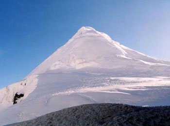 The peak, which lies due south of the Tesi Lapcha, is unnamed on the Schneider Rolwaling Himal map, but is given a spot height of (6,273m) (20,581ft). The Mandala Lamasangu to Everest map calls the peak Parchoma, which is quite possibly a spelling mistake. Both Shipton's and Gregory's expedition surveys gave the peak an altitude close to (6,318m) (20,700ft). It is a straightforward snow peak first climbed in 1955.The scenery is outstanding, the route leads.
Along beautiful river valleys before emerging in high alpine country and there are excellent views of Gaurisankar, Melungtse and many other great peaks. The Rolwsaling valley is the main access to Pachermo.Seen from the pass the mountain is an attractive but straightforward snow peak with a well defined north by north west ridge rising from the relatively flat, crevassed glacier astride the Tesi Lapcha.
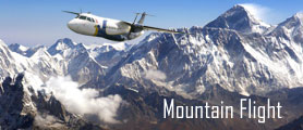
One is from Dolakha/Charikot rout. This route is bit difficult then other route. The other route is flying to Luka and trek to Namche, Thame to base and high camp. Lukla route is more comfortable than the other route.
Parchamo peak is the most popular climbing peak for trekkers who are crossing the high Tashi Lapcha Pass (5,755m) to Khumbu Valley in the Everest region.The-climbing program can be jointly merged with the more challenging Rolwaling valley trek. Essentially, Pharchemo climbing program with Tashi Lapcha pass unites the two Sherpa territories, Rolwaling Valley and Khumbu region. These two areas are two diverse trekking regions with distinct mountain views wherein Rolwaling is recognized as the less discovered and Khumbu more inclined towards tourism. Nevertheless, both regions being in habited by similar communities of people the Sherpa whose chief occupation is mountain climbing. Members of the highly successful Merseyside Himalayan Expedition led by Alf Gregory, Dennis Davis and Phil Boultgee summarize some of an interesting early history of this mountain in 1955. Besides, peak climbing nineteen summits in and around Rolwaling Valley, their exploration landed at the head of the Drolambau and further proceeds towards climbing numerous peaks up the Ripimu Glacier and into the Menlung Basin via the Ripimu La.
Trek Features
Duration day in Nepal: 17 days
Total duration treks: 14 days
Trek style: Fully : Camping trekking/ Lodge trekking
Trek starts/ends: to Lukla / Lukla
Max elevation: 6273mt.
Trek grading: Moderate/ Demanding
Best season: March-May, October-November
Accommodation: 4 nights in hotels in Kathmandu on bed and breakfast and 13 nights in Camping with breakfast, lunch and dinner.
Trip highlights
Pristine and isolated region
Breathtaking mountain views
Diverse mountain flora and fauna
Trip Details Itinerary
Day 01: Arrive Kathmandu, transfer to airport
Day 02: In Kathmandu- free day, sort out permit & equipment
Day 03: Fly to Lukla (2800mt.) trek to Phakding (2680mt.)
Day 04: Phakding trek to Namche Bazaar (3440mt.)
Day 05: Namche Bazaar trek to Thame village (3800mt.)
Day 06: Day free at Thame to Acclimatization
Day 07: Thame trek to Thengpo (4350mt.)
Day 08: Thengpo trek to Tashi Phung base camp (5110mt)
Day 09: Summit Parchamo peak (6187mt.) and back to Thengpo
Day 10: Thengpo trek to Thame (3480mt.)
Day 11: Thame trek to Khumjuing (3753mt.)
Day 12: Khumjuing trek to Namche Bazar (3440mt.)
Day 13: Namche Bazar trek to Phakding
Day 14: Phakding trek to Lukla
Day 15: Lukla Fly to Kathmandu
Day 16: In Kathmandu, free day
Day 17: Transfer to airport, depart Kathmandu